
How to Read Sectional Charts for the Part 107 Exam
12 min read ·

Co-founder of MindMax and Memrise, Grand Master of Memory
How do I read sectional charts for the Part 107 exam?
To read sectional charts for the Part 107 exam, learn a few fixed rules and apply them in the same order every time. Chart altitudes are in feet MSL unless marked otherwise, while your drone flies in feet AGL, so subtract the ground or field elevation. Solid blue is Class B, solid magenta is Class C and dashed blue is Class D, and all three need authorization. A dashed magenta line means Class E from the surface, which also needs authorization. A shaded magenta band means Class E starts at 700 feet AGL, with Class G below it.
Why chart questions feel hard at first
If you feel totally lost right now, you are in good company. Candidates describe charts as "incredibly perplexing" in week one and then call them easy points a few weeks later. One tester put it bluntly. "If sectional charts aren't the easiest part of the exam for you, it means you haven't studied enough." Another guessed that about 20% of their questions involved charts.
The test itself is the FAA's Unmanned Aircraft General, Small (UAG) knowledge test. You get 60 multiple choice questions, up to two hours, and you need 70% to pass, which is 42 correct. You may use plotters, a straightedge and a simple calculator, and the proctor gives you the testing supplement. For a question with a graph, you can ask for a printed copy you can mark.
What changed for chart questions on October 26, 2026
The FAA's Airman Testing Community Advisory, September 2026 Special Edition, announced that from October 26, 2026 the UAG test includes image-based questions not found in the test supplements. These use up-to-date images from the latest Sectional Charts, and you cannot preview them before the test.
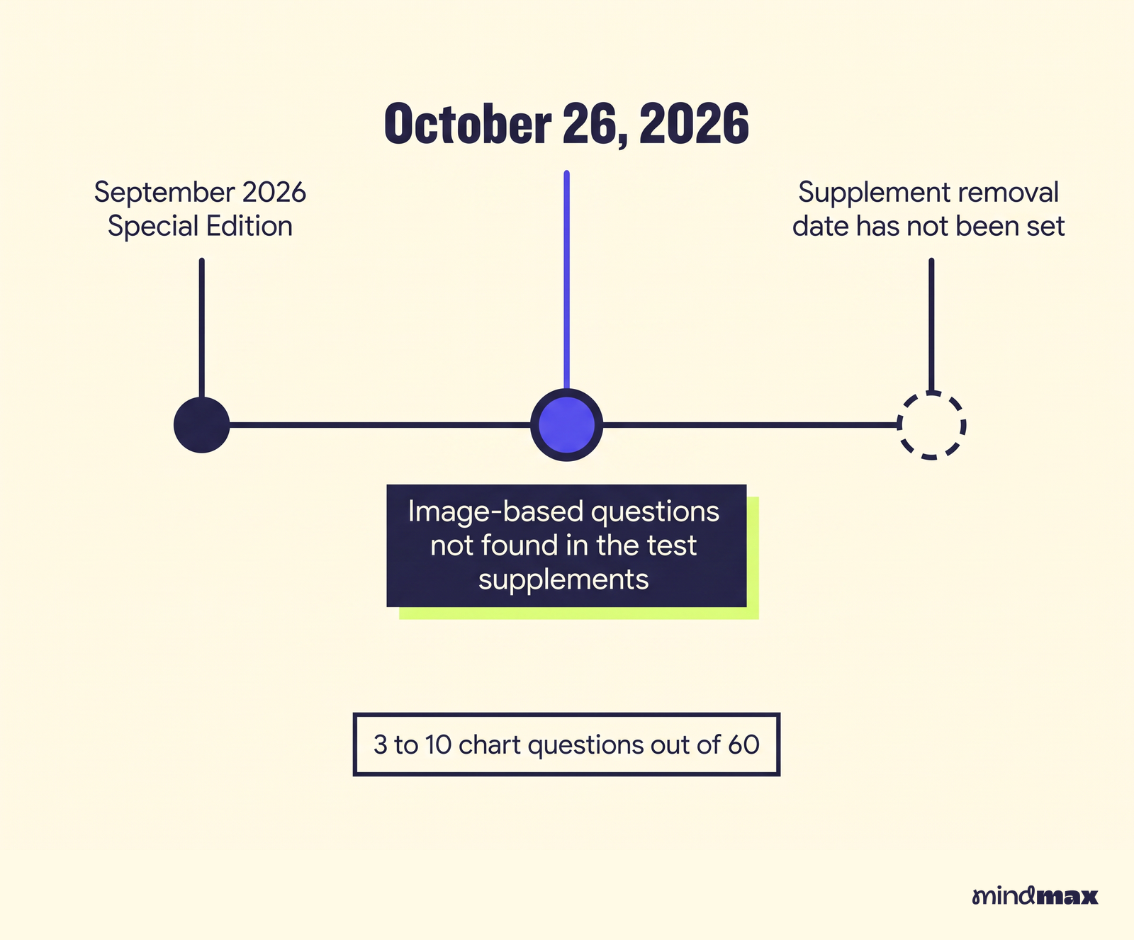
The supplement has not gone away yet. The supplement removal date has not been set, so you still get it on test day. The FAA recommends the PSI True Talent sample questions to see the new format.
It published two official UAG samples.
- A Millville Muni (MIV) question on the Washington sectional. The answer is "Class E that is associated with an airport surface area, authorization is required."
- The CTAF at Grand Canyon (GCN) when the tower is closed. The answer is 119.0.
A small group of three testers who sat the new version reported 3 to 10 chart questions out of 60. Two of the three saw unfamiliar crops of current sectionals. The simple ones asked about an unmarked magenta airport, Class G versus Class E at 700 feet AGL under the shading, and reading a CTAF from a data block. The harder one showed a wider image and asked about the airspace 400 feet above a tower being inspected. It was Class C, so authorization was required.
The lesson is simple. Memorizing the supplement figures is no longer enough. You need to read any sectional, cold.
When do you use MSL vs AGL on chart questions?
The FAA Aeronautical Chart Users' Guide page states the default plainly. "Unless otherwise indicated" altitudes on the chart are feet above Mean Sea Level. The exceptions are few, so learn them.
- Class B. Ceiling and floor of each sector are solid blue figures with the last two zeros dropped. A floor marked with a plus sign means the floor is above that altitude.
- Class C. The same format, in solid magenta figures. A ceiling of "T" means up to, but not including, the floor of the Class B above.
- Class D. A dashed blue line. A minus sign in front of the ceiling figure means from the surface up to, but not including, that altitude.
- Obstacles. The big number is the MSL top. The AGL height sits in parentheses below it. A tower marked 1549 with (349) beneath is 1,549 feet MSL at the top and 349 feet tall.
- Airport elevation. The highest point on the usable landing area, in MSL.
- Class E floors. These are the AGL exception. 700 feet AGL inside the magenta shading, and 1,200 feet AGL by default.
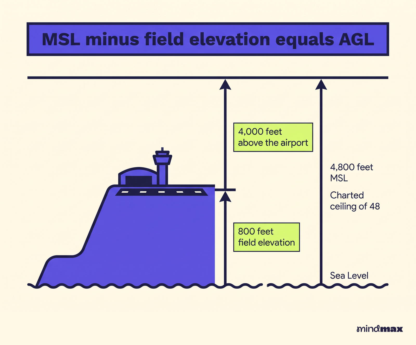
Your drone's altitude is always AGL, so convert everything to AGL before you compare. The working formula is MSL minus field elevation equals AGL.
A worked example
Say a Class C airport sits at 800 feet field elevation. Class C usually reaches 4,000 feet above the airport, but the chart prints it in MSL. You would see a charted ceiling of 48, which means 4,800 feet MSL. Subtract 800 and you are back at 4,000 feet above the airport.
The classic traps
The FAA likes answer choices that mix the two. One candidate got a Class E floor question where every choice was in MSL, so they had to find the airport elevation and add 700. Another saw a Class D ceiling question offering both "2,800 feet AGL" and 2,800 feet MSL. The chart figure is MSL, so the AGL option is the trap. Read the units in every answer before you pick.
What does shaded vs dashed magenta mean for drones?
These two symbols cause more confusion than anything else on the chart. The Chart Users' Guide wording is short.
- "Class E Surface (SFC) Airspace is symbolized with a magenta dashed line."
- "Controlled airspace floors of 700' above the ground are defined by a magenta vignette." A vignette is the fuzzy shaded band.
- Floors other than 700 feet that border Class G use a blue vignette.
- "Class E Airspace exists at 1200' AGL unless designated otherwise."
- Class G can extend up to 14,500 feet MSL.
| Chart symbol | What it is | Floor | Drone at 400 ft AGL |
|---|---|---|---|
| Dashed magenta line | Class E surface area | Surface | Authorization required |
| Shaded magenta band | Class E above Class G | 700 ft AGL | No authorization needed |
| Shaded blue band | Class E above Class G | Other charted floor | Read the floor |
| No shading | Class E above Class G | 1,200 ft AGL | No authorization needed |
| Dashed blue line | Class D | Surface | Authorization required |
One more color clue. Towered airports and their data are printed in blue. All other airports are magenta.
How to tell Class E to the surface from Class G up to 700 feet
Ask two questions in order.
- Is there a dashed magenta line around the spot? If yes, Class E starts at the surface. Authorization required.
- If not, are you inside the shaded magenta band? Then Class G from the surface to 700 feet AGL sits under the Class E. No authorization needed at 400 feet.
The FAA Study Guide backs this up. Class G "extends from the surface to the base of the overlying Class E airspace," and a remote pilot does not need ATC authorization to fly in it. Authorization under 14 CFR 107.41 covers Class B, C and D, plus the lateral boundaries of a Class E surface area designated for an airport. The MIV sample question above is exactly this test.
Class B and Class C airspace rings and altitudes
The FAA Study Guide describes both shapes, and they are where the "upside-down wedding cake" comes from.
Class B generally runs from the surface to 10,000 feet MSL around the busiest airports. Each one is individually tailored, with a surface area and two or more layers above it. Each sector shows a fraction like 100 over 40, which means a ceiling of 10,000 feet MSL and a floor of 4,000 feet MSL, because the last two zeros are dropped.
Class C is more standard. An inner circle with a 5 NM radius runs from the surface to 4,000 feet above the airport. An outer circle with a 10 NM radius runs from 1,200 to 4,000 feet above the airport. All of it is charted in MSL, so the printed numbers include the field elevation.
Under the outer ring, below its floor, you are not in Class C. Check what lies underneath, often Class E or Class G. Over flat ground near field elevation, a drone at 400 feet AGL under the outer ring sits below the 1,200 foot floor. This is where people slip. As one tester warned, watch the tiered layers of Classes B and C and their MSL or AGL designations for each ring. Convert each shelf to AGL using the ground elevation below it before you decide whether your 400 feet touches it.
You need authorization for Class B, C and D. In real flying that often means LAANC, which gives near-real-time approval at participating airports.
Class D and the Mode C veil
Class D runs from the surface to 2,500 feet above the airport elevation, charted in MSL inside a dashed blue line. The Mode C veil is a thin solid magenta circle 30 NM around a Class B primary airport, from the surface to 10,000 feet MSL. It is a transponder rule for manned aircraft, not a new airspace class, so do not mistake it for Class C.
Reading the airport data block
The text next to each airport packs a lot into one line, and the new test uses it for easy questions.
- Color. Blue means a towered airport. Magenta means non-towered.
- CTAF. The common traffic advisory frequency, the one you would listen on when no tower is running.
- Star. A star by the tower frequency means the tower is part-time. When it closes, use the CTAF, as in the Grand Canyon sample.
- Field elevation. In feet MSL. This is the number you subtract in MSL questions.
- Runway length. The longest runway in hundreds of feet, so 52 means 5,200 feet.
How to do latitude and longitude questions
These questions ask you to find a spot from coordinates, or name the coordinates of a spot. The basics from the FAA Study Guide are enough.
Lines of latitude run east to west, and latitude increases going north. Lines of longitude run pole to pole, and in the US longitude increases going west. The 48 contiguous states sit between 25 and 49 degrees north and between 67 and 125 degrees west. Washington, D.C. is about 39 degrees north, 77 degrees west.
A sectional is drawn at 1 to 500,000, so 1 inch is about 6.86 NM. Ticked lines divide the chart into blocks of 30 minutes of latitude and 30 minutes of longitude.
The usual teaching method, widely used though not an FAA quote, treats each small tick as 1 minute. Find the nearest labeled latitude line below the point and count ticks upward. Then find the nearest labeled longitude line east of the point and count ticks westward. Write latitude first, then longitude, and match it against the choices.
Don't overinvest here. One candidate worked hard on lat and long and got none. A handful of practice questions is usually plenty.
Best way to practice sectional chart questions
The right tool depends on how you learn and what you want to spend.
| Option | Cost | Best for |
|---|---|---|
| FAA Study Guide, Chart Users' Guide, free current sectionals | Free | Self-starters who like source documents |
| PSI True Talent sample questions | Free | Seeing the October 2026 question format |
| Drone U course | $147, regularly $197, per its own page | Learners who want instructor walkthroughs of charts |
| Drone U free practice test and study guide PDF | Free | A quick check before paying for anything |
| Altitude University | About $100, per one tester | A course bundled with 5 practice tests |
| King Schools practice exams, Flight Ready app | Not confirmed | Extra question volume |
Drone U's course adds on-demand video, FAA-aligned quizzes where 90% or higher signals you're ready, community access, lifetime access and a 14-day money-back guarantee. For a wider look at paid and free options, see our comparison of the best online courses to pass the Part 107 exam.
A routine that works for the new format
- Learn the legend first. Spend an evening on the symbols above until you can name each without looking.
- Practice on unfamiliar charts. Download a current sectional for a region you have never flown. Pick random spots and ask what airspace sits at 400 feet AGL. One retaker's advice was to click around on SkyVector until it makes sense.
- Convert every altitude out loud. Say the MSL figure, the ground elevation and the AGL result each time.
- Mix in practice tests. Wait until you score above 90% consistently, and expect your real score to run a little lower.
- Use your score report. It lists ACS codes for missed questions, so a fail points straight to the airspace items you need.
If you want a structured plan, MindMax is an adaptive personal tutor app from Ed Cooke and Daniel Zohar, who built Memrise, used by over 80 million people. It starts from your goal of passing and maps out bite-sized lessons timed for your day, with a clear plan and daily check-ins, whether you have months or days left. Each lesson is a conversation with a tutor you pick, so you can ask questions as you go and the lesson adapts, which helps when MSL and AGL still feel slippery.
On test day, bookmark the chart legend in the supplement. Plenty of passers give the same advice. Don't forget the chart key. For how much study time most people need overall, see how hard the Part 107 test is and how long to study.
Frequently asked questions
Are TFRs and NOTAMs shown on sectional charts?
Mostly no. The Chart Users' Guide says only TFRs relating to national security are charted. The test does cover the NOTAM system, so learn how to check NOTAMs before a flight rather than relying on the chart.
What do restricted areas, MOAs and military training routes mean for drone pilots?
Special use airspace is also tested. Prohibited, restricted, warning and alert areas are marked with the letters P, R, W and A, and MOAs are military operations areas. A military training route with a four-digit number has no segment above 1,500 feet AGL.
Do I need an instructor endorsement to retake the test if I fail the chart questions?
No. You wait 14 calendar days after a failed attempt and bring your failed test report, but no instructor endorsement is needed. Use the ACS codes on that report to target the airspace topics you missed.
How much does the Part 107 test cost?
Candidates report paying about $175 per attempt to PSI, and a retake costs the full fee again. That figure comes from candidates and prep providers, so confirm the current price when you book with PSI.
How do I get authorization to fly in Class B, C, D or a Class E surface area in real life?
At participating airports you can use LAANC, which gives near-real-time approval. Plan the request before you arrive on site, since flying in that airspace without authorization breaks Part 107.